

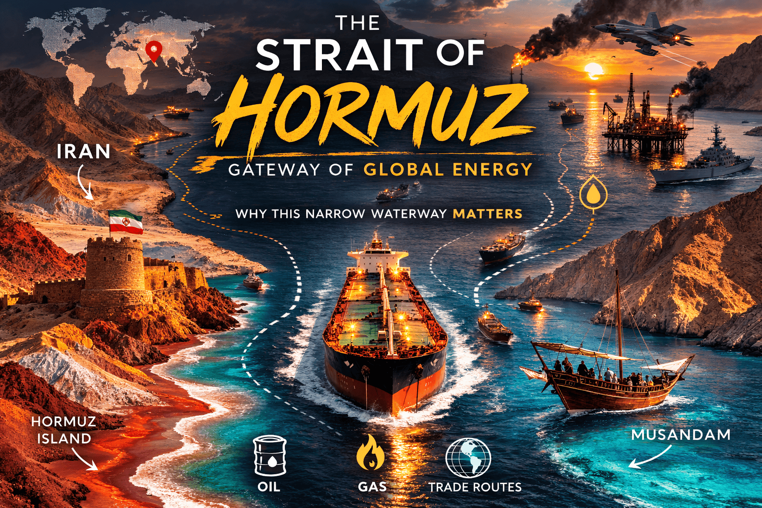
🌍 What Is the Strait of Hormuz?
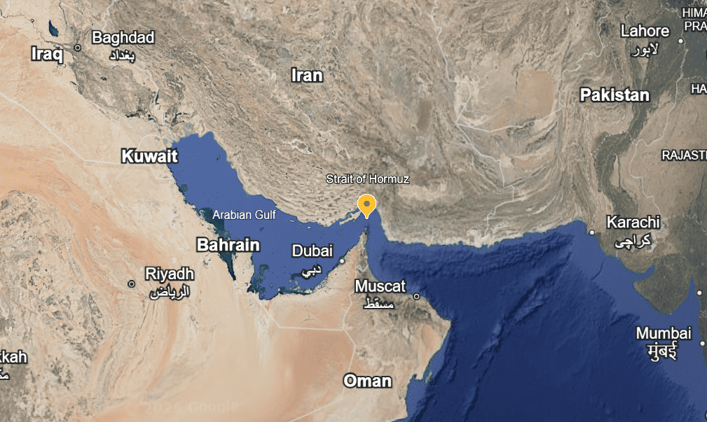
The Strait of Hormuz is a narrow waterway that connects the Persian Gulf to the Gulf of Oman and the Arabian Sea. It lies between Iran (to the north) and Oman (to the south), with the United Arab Emirates nearby. It’s the only sea route for tankers to carry oil and gas out of the Gulf to the rest of the world. (Encyclopedia Britannica)
Because of this, it’s one of the most strategic waterways in the world — a vital global energy lifeline and geopolitical hotspot. (scrolli.co)
💡 Why Is the Strait of Hormuz Important?
⚓ 1. Global Energy Supply
- Around 20 million barrels of oil per day — about 20 % of the world’s oil consumption — passes through this strait. (scrolli.co)
- It carries a significant share of global liquefied natural gas (LNG) exports too. (ugm.com.tr)
This makes the strait a major chokepoint — meaning any disruption (real or threatened) can impact global fuel prices, inflation, shipping costs, and even economic stability far beyond the Middle East. (ExpertFile)
🛡 2. Geopolitical Flashpoint
- Iran controls the northern side of the strait and has threatened to disrupt traffic in past conflicts. (scrolli.co)
- The U.S. Fifth Fleet, based in Bahrain, regularly patrols the area to protect shipping. (Reuters)
Because of this mix of oil, geography, and military presence, the Strait of Hormuz is often at the center of Middle East tensions.
📜 Brief History & Geopolitical Context
The Strait has been significant for international trade for centuries, but its modern strategic importance grew with the rise of oil exports in the 20th century. (ExpertFile)
🕰 Historical Highlights
- 1980s “Tanker War” — During the Iran–Iraq War, both sides attacked each other’s tankers and those of other Gulf states; Western navies intervened to keep oil flowing. (Encyclopedia Britannica)
- 1979 Iranian Revolution — Increased tensions as Iran’s regional policies shifted. (ExpertFile)
- Recent Decades — Periodic naval standoffs, threats to close the strait in crises, and repeated international naval patrols have become normal. (Encyclopedia Britannica)
⚠ Current Tensions (2025–2026)
In the latest conflict involving Iran and U.S./Israeli forces:
- Major commercial vessels have been attacked near the strait. (Business Insider)
- Iran’s Revolutionary Guards have broadcast warnings that no ship may pass — causing uncertainty. (Reuters)
- Shipping traffic dropped sharply amid safety fears. (Reddit)
- Global oil prices spiked on fears of disruption. (The Washington Post)
- Check strait of Hurmuz news
- strait of hormuz open
These events show how closely geopolitics and global energy markets are tied to what happens in this narrow channel.
🧳 Visiting the Strait of Hormuz — What to Know
📍 Is It a Tourist Destination?
The strait itself isn’t a traditional tourist site in the sense of beaches or cities. It’s a working shipping route and strategic waterway.
However, nearby places like:
- Hormuz Island (Iran) — known for colorful landscapes, salt caves, and local culture, in safer times people visit as an off-the-beaten-path spot.
- Musandam Peninsula (Oman) — offers dramatic fjords, marine wildlife, and dhow cruises (best when the regional security situation is stable).
🗓 Best Time to Visit Region
Autumn to Spring (October–April) is generally considered the most pleasant season for travel in the Gulf region — cooler temperatures, clearer skies, and more comfortable conditions for outdoor activities.
⚠ Important Safety Note:
Right now (early 2026), this region is experiencing high geopolitical tensions and reported attacks on vessels near the Strait of Hormuz. Maritime authorities and insurers are warning ships and companies to exercise caution, and many are avoiding the area. Travel here is not recommended at this time due to security risks. (Reddit)
🧠 Quick Recap
- 📍 Location Strait of Hormuz map: Between Iran and Oman, a key gateway from the Persian Gulf to the open ocean. (Encyclopedia Britannica)
- 🚢 Strategic Role: Handles ~20 % of the world’s daily oil exports and major LNG flows. (scrolli.co)
- ⚔ History: A crossroads of naval power struggles, especially during the Iran–Iraq War and ongoing Middle East tensions. (ExpertFile)
- 🧳 Travel: Best visited in cooler seasons if peace and safety return — for now, avoid due to current conflict risks.
🇮🇷 Visiting Hormuz Island (Iran Strait of Hormuz)
If the Strait of Hormuz is geopolitics, Hormuz Island is pure art.
🌈 What Makes It Special?
Hormuz Island feels almost Martian. The soil is red, orange, purple, and yellow — caused by rich mineral deposits. Locals even use the red earth (“gelack”) in traditional cooking and cosmetics.
Top Things to See
1️⃣ Rainbow Valley
Layered mineral mountains that look painted by hand.
2️⃣ Red Beach
Iron-rich sand that literally turns the shoreline crimson at sunset.
3️⃣ Salt Goddess Cave
A surreal salt cavern with white crystalline formations.
4️⃣ Portuguese Fort
Built in the 1500s when Portugal controlled the Strait — a reminder of how long global powers have fought over this waterway.
🧳 Travel Tips for Hormuz Island
- You’ll typically fly into Bandar Abbas, then take a ferry.
- Modest dress is required.
- English is limited — a local guide helps.
- Bring cash (sanctions affect card usage).
🗓 Best Time to Visit
November to March — cool desert temperatures (20–28°C).
Avoid summer (May–September); it can exceed 45°C.
🇴🇲 Visiting the Musandam Peninsula (Oman)
Now cross to the southern side of the strait.
Musandam feels completely different — rugged cliffs dropping into turquoise water. It’s often called the “Norway of Arabia.”
🌊 Why Travelers Love It
You can sail traditional wooden dhows through dramatic fjord-like inlets while massive oil tankers silently pass in the distance — a surreal contrast of nature and global commerce.
Top Experiences
1️⃣ Dhow Cruise in Khasab
Slow sailing through calm waters with dolphin sightings.
2️⃣ Snorkeling & Diving
Clear waters, coral reefs, and marine life.
3️⃣ Jebel Harim (“Mountain of Women”)
Highest peak in Musandam — stunning panoramic views of the Strait.
4️⃣ Telegraph Island
Historic British telegraph station from the 1860s — when the British Empire controlled communications through this passage.
🧳 Travel Tips for Musandam
- Fly to Dubai, then drive (~3 hours) to Khasab.
- Border crossing requires passport checks.
- Roads are mountainous — 4×4 recommended for interior exploration.
🗓 Best Time to Visit
October to April — mild and pleasant (18–30°C).
Summers are extremely humid and uncomfortable.
⚓ A Quick Historical Snapshot of the Strait
The Strait of Hormuz has shaped empires for centuries.
- 16th century: Portuguese naval dominance
- 19th century: British strategic control
- 1980s: “Tanker War” during the Iran–Iraq conflict
- Modern era: Roughly 20% of the world’s oil supply passes through daily
Standing here, you realize this narrow 33 km-wide channel influences fuel prices in New York, London, and Tokyo.
It’s not just geography — it’s global power.
⚠️ Important Reality Check (2026 Context)
Because you’re currently in Doha, Qatar, you’re geographically close. However:
- The Strait frequently experiences geopolitical tension.
- Naval patrols are common.
- Travel advisories fluctuate quickly.
Before planning any visit, check official government travel advisories and regional news updates.
🌅 So… Is It Worth Visiting?
If conditions are stable — absolutely.
Hormuz Island is raw, artistic, and unlike anywhere else in the Middle East.
Musandam is peaceful, dramatic, and surprisingly accessible.
But this isn’t a casual beach holiday destination. It’s a place where nature, history, and global politics collide.
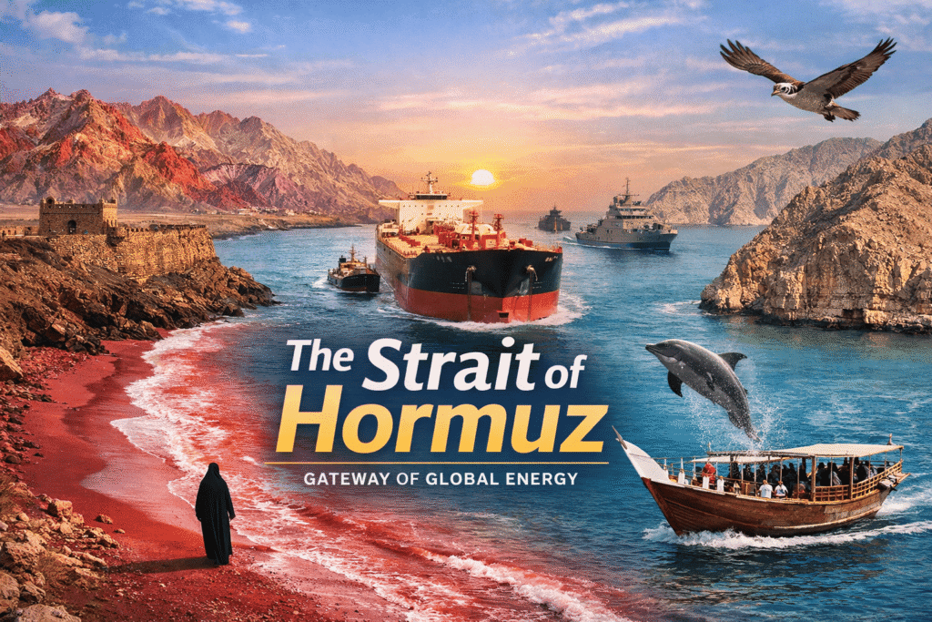
The Strait of Hormuz
Connecting the Persian Gulf to the Gulf of Oman, it is the world’s most important oil transit chokepoint and a region of stunning natural beauty.
🛢️ Geopolitical & Economic Importance
The Strait of Hormuz is the vital artery of the global energy supply. At its narrowest point, it is only 21 miles wide, yet it accommodates a staggering portion of the world’s petroleum and natural gas trade. Any disruption here sends immediate shockwaves through global markets.
Daily Oil Transit
Barrels per day passing through the strait, roughly 21% of global petroleum liquids consumption.
Global Seaborne Oil Trade
Comparing the volume of oil moving through Hormuz versus all other maritime routes worldwide.
Top Exporters Relying on the Strait
Millions of barrels per day exported by Middle Eastern nations via the Hormuz chokepoint.
🗺️ A Brief History of Conflict & Trade
For centuries, empires have vied for control of this strategic waterway. From early spice routes to modern energy wars, whoever controls the Strait of Hormuz wields immense global influence.
16th Century: Portuguese Era
The Portuguese Empire captures Ormuz (Hormuz Island) in 1515, controlling the lucrative spice and silk trade routes between India and Europe for over a century.
17th – 19th Century: British Dominance
A joint Anglo-Persian force expels the Portuguese. By the 19th century, the British East India Company secures treaties with local sheikhdoms to protect sea lanes to India.
1984 – 1988: The Tanker War
During the Iran-Iraq War, both nations attack merchant shipping and oil tankers in the strait, leading to major US naval intervention (Operation Earnest Will) to protect Kuwaiti oil.
2010s – Present: Modern Tensions
Recurring geopolitical standoffs, vessel seizures, and attacks on tankers characterize the modern era, heavily tied to international sanctions and regional rivalries.
☀️ Tourism: Best Time to Visit
Despite its geopolitical reputation, the Musandam Peninsula (Oman) and Qeshm/Hormuz Islands (Iran) offer spectacular tourism. Known as the “Norway of Arabia,” the region features dramatic fjords, dolphin watching, and vibrant red beaches. The climate, however, strictly dictates travel plans.
Ideal Season: Nov – March
Temperatures are highly pleasant, hovering between 20°C and 27°C (68°F – 80°F). The water is perfect for dhow cruises and snorkeling.
Avoid: June – September
Extreme heat and humidity. Temperatures regularly exceed 40°C (104°F) making outdoor activities dangerous and uncomfortable.
Average Climate Conditions (Musandam/Hormuz)
Average monthly high temperatures showing the clear window for optimal travel.
The Strategic Nexus of the Strait of Hormuz: A Comprehensive Geopolitical, Historical, and Maritime Analysis
The Strait of Hormuz stands as the most critical maritime chokepoint in the global energy landscape, a narrow artery of water that dictates the economic pulse of nations and the strategic posturing of empires. Connecting the Persian Gulf to the Gulf of Oman and the Arabian Sea, this waterway serves as the singular exit for the vast hydrocarbon wealth produced by the littoral states of the Gulf. For the global traveler and the geopolitical analyst alike, the strait is not merely a geographic feature but a theater of historical persistence, where ancient trade routes intersect with modern military tensions and profound human tragedies. The following report provides an exhaustive examination of the strait’s physical parameters, its vital role in global trade, its “grief history” of conflict, and the unique cultural and natural wonders that define its surrounding regions.
Geographic Foundations and Navigational Constraints
The physical dimensions of the Strait of Hormuz are paradoxically modest given its global significance. Stretching approximately 104 nautical miles (193 kilometers) in length, the strait separates the southern coast of Iran from the Musandam Peninsula, an exclave of the Sultanate of Oman. Its width varies significantly, reaching its maximum of roughly 52.5 nautical miles (97 kilometers) before constricting to its narrowest point of 21 nautical miles (39 kilometers) between the Omani island of Great Quoin and the Iranian shore.
Bathymetry and Tactical Geography
The seafloor topography of the strait creates a distinct navigational and tactical environment. The deepest waters, exceeding 200 meters (650 feet), are concentrated along the southern coast near the Musandam Peninsula. As one moves north toward the Iranian coastline, the depth tapers significantly, with some sections falling below 25 meters. This bathymetric profile dictates the movement of the world’s largest vessels. Fully laden Very Large Crude Carriers (VLCCs), which typically have a draft of 20 to 25 meters, are restricted to specific deep-water channels, primarily within Omani territorial waters.
The constraints of the strait necessitate the use of a Traffic Separation Scheme (TSS) to manage the intense volume of commercial traffic. This scheme consists of two shipping lanes—one for inbound and one for outbound traffic—each measuring two miles (3.2 kilometers) in width, separated by a two-mile wide buffer zone. This narrow configuration leaves little room for maneuver, making ships vulnerable to naval mines, shore-launched missiles, and harassment by small patrol craft, particularly given the close proximity of the Iranian coast.
Table 1: Physical and Navigational Parameters of the Strait of Hormuz
| Feature | Specification | Source |
| Total Length | 104 nmi (193 km) | |
| Minimum Width | 21 nmi (39 km) | |
| Maximum Width | 52.5 nmi (97 km) | |
| Maximum Depth | >200 meters | |
| Shipping Lane Width | 2 miles (inbound/outbound) | |
| Buffer Zone Width | 2 miles | |
| Primary Basin | Persian Gulf to Gulf of Oman |
Strategic Islands and Territorial Claims
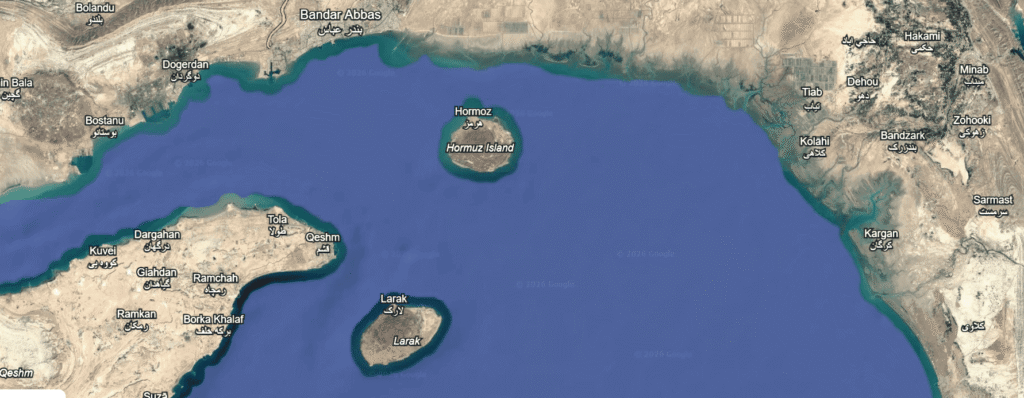
The waterway is punctuated by several islands that serve as stationary sentinels over the passing traffic. Iran controls the majority of the major islands, including Hormuz, Qeshm, Larak, and Hengam. Qeshm Island, the largest in the region at approximately 115 kilometers in length, is rich in natural gas and salt resources and serves as a significant administrative and military hub.
A significant source of regional tension involves the islands of Abu Musa, Greater Tunb, and Lesser Tunb. Situated near the western approach to the strait, these islands have been under Iranian military control since 1971, though they are subject to a long-standing sovereignty dispute with the United Arab Emirates (UAE). Iran’s de facto control of these islands provides it with a commanding vantage point over the primary shipping lanes, reinforcing its influence over the flow of energy exports.
Economic Imperatives and Energy Security
The Strait of Hormuz is widely characterized by the U.S. Energy Information Administration (EIA) as the world’s most critical oil chokepoint. Its importance is fundamentally tied to the volume of crude oil, condensate, and petroleum products that transit the passage daily.
Global Energy Flows
During the early 2020s, oil flows through the strait averaged between 20 and 21 million barrels per day (mb/d). This volume represents approximately 20% to 25% of the world’s total seaborne oil trade and roughly one-fifth of global petroleum liquids consumption. The waterway is the primary export conduit for members of the Organization of the Petroleum Exporting Countries (OPEC), including Saudi Arabia, Iran, Iraq, Kuwait, and the UAE.
The reliance on this passage is even more pronounced for the global Liquefied Natural Gas (LNG) market. Approximately 20% of global LNG trade, primarily from Qatar and the UAE, must pass through the strait. Unlike oil, for which some limited pipeline alternatives exist, there are no practical alternative routes for the vast quantities of LNG produced in the Gulf, making this sector uniquely vulnerable to maritime disruptions.

Table 2: Daily Energy Transit Volumes (Average 2023-2024)
| Commodity | Volume (Daily) | % of Global Seaborne Trade | Source |
| Crude Oil & Condensate | ~17.5 – 20 mb/d | ~25% | |
| Petroleum Products | ~2.5 – 3.5 mb/d | ~15% | |
| LNG | ~100-110 million tonnes/year | ~20% |
The “Pipeline Myth” and Bypass Realities
While Saudi Arabia and the UAE have invested in infrastructure to bypass the Strait of Hormuz, the total capacity of these alternatives remains insufficient to mitigate a full closure. The Saudi East-West Pipeline (Petroline) has a nameplate capacity of approximately 5.0 mb/d, while the UAE’s Habshan–Fujairah pipeline can transport roughly 1.5 to 1.8 mb/d to the Gulf of Oman. Additionally, Iran recently inaugurated the Goreh-Jask pipeline with a capacity of 300,000 b/d. Even if these pipelines operated at maximum capacity, over 70% of the regional oil exports would still require maritime transit through Hormuz.
Dependence of Asian Markets
The vulnerability of the strait has a disproportionate impact on Asian economies. Approximately 80% to 84% of the crude oil and condensate moving through the strait is destined for Asian markets. China, India, Japan, and South Korea are the primary consumers, collectively accounting for 67% to 69% of the total volume. For India, the strait is particularly vital; nearly 40% to 50% of its crude imports and roughly half of its LNG supplies transit the route. Any disruption in Hormuz is immediately felt in India through increased freight and insurance costs, rising inflation, and pressure on the rupee.
The Historical Tapestry: From Antiquity to Colonial Control
The Strait of Hormuz has been a commercial crossroads for over 4,000 years, acting as a bridge between the civilizations of Mesopotamia and the Indus Valley. Its role as a conduit for luxury goods—including spices, silk, porcelain, and almonds—has made it a focal point for every major empire seeking to control the trade routes of the Indian Ocean.
The Kingdom of Ormus
The Kingdom of Ormus, which flourished between the 10th and 17th centuries, represents the peak of indigenous commercial power in the strait. Originally a mainland entity, the kingdom relocated its capital to the island of Jarun (modern-day Hormuz Island) in the 13th century to better manage the narrow passage and defend against marauding groups. Ormus became a legendary entrepôt, where merchants from China, India, East Africa, and the Mediterranean gathered. The kingdom was so prosperous that its name became synonymous with immense wealth in early modern literature.
Portuguese Hegemony and the Cartaz System
The arrival of the Portuguese in the early 16th century marked the beginning of European colonial intervention. Led by Afonso de Albuquerque, the Portuguese attacked Hormuz in 1507 as part of a grand strategy by King Manuel I to thwart Muslim trade in the Indian Ocean. Despite significant resistance, the Portuguese established a fort and turned the kingdom into a vassal state.
For over a century, the Portuguese maintained control through the cartaz system—a maritime license required for all merchant vessels operating in the region. This allowed Portugal to tax and redirect global trade, effectively turning the Strait of Hormuz into a source of revenue for the Portuguese crown. The “Portuguese Castle,” still standing on the northern tip of Hormuz Island, remains a stark architectural reminder of this era of domination.
The 1622 Siege and the Rise of British Influence
The Portuguese monopoly was eventually broken in 1622 by a joint force of the Persian Safavid Empire under Shah Abbas I and the British East India Company. The collaboration was driven by mutual interest: the Persians sought to regain sovereignty over their coastal lands, while the British aimed to secure favorable terms for the burgeoning silk trade. The fall of the Portuguese fort at Hormuz led to a fundamental shift in regional power. The center of trade was moved from the island of Hormuz to the newly founded mainland port of Bandar Abbas (named in honor of the Shah). This event inaugurated a period of British naval dominance in the Gulf that would persist until 1971.
The “Grief History”: Tragedies of the Modern Era
The strategic importance of the Strait of Hormuz has frequently made it a theater for devastating conflict and human suffering. This “grief history” is most poignantly illustrated by the events of the late 20th century, particularly the “Tanker War” and the tragic shootdown of Iran Air Flight 655.
The Tanker War (1980–1988)
During the eight-year Iran–Iraq War, the Strait of Hormuz became the front line of an economic war of attrition. Iraq began attacking Iranian oil terminals and tankers in 1981 to cripple Tehran’s ability to fund its war effort. Iran retaliated by targeting vessels belonging to Iraq’s trading partners and neutral Gulf nations that provided financial support to Baghdad.
This period saw the deployment of advanced naval weaponry, including French-made Exocet missiles and Iranian-deployed Silkworm missiles. More than 500 ships were damaged or destroyed in what remains the most intensive anti-shipping campaign since World War II. The conflict eventually drew in the United States, leading to Operation Earnest Will, where the U.S. Navy escorted “re-flagged” Kuwaiti tankers to ensure the continued flow of oil.
Table 3: Significant Incidents of the Tanker War (1981–1988)
| Date | Incident | Context | Source |
| May 1981 | Iraq declares “Prohibited War Zone” | Escalation of attacks on shipping to Iranian ports. | |
| May 1982 | Hit on Atlas I | First oil tanker hit during the conflict. | |
| May 1987 | Attack on USS Stark | Iraqi aircraft kills 37 U.S. sailors in a misidentification. | |
| April 1988 | Operation Praying Mantis | U.S. retaliates for mine damage to USS Samuel B. Roberts. | |
| July 1988 | Iran Air Flight 655 | Shootdown of civilian airliner by USS Vincennes. |
The Tragedy of Iran Air Flight 655
The most profound human tragedy in the history of the strait occurred on July 3, 1988. During a naval skirmish between the USS Vincennes and Iranian gunboats, the U.S. cruiser mistakenly identified a civilian airliner as an attacking Iranian F-14 Tomcat. The aircraft, an Airbus A300 operating as Iran Air Flight 655, was on a routine 28-minute flight from Bandar Abbas to Dubai.
Despite the plane transmitting civilian transponder codes, the crew of the Vincennes, operating under high-stress combat conditions, fired two surface-to-air missiles. The plane was struck over Iranian territorial waters, killing all 290 people on board, including 66 children. This event continues to cast a long shadow over U.S.-Iran relations, cited by the Iranian government as a symbol of American disregard for Iranian life.
The March 2026 Crisis: A Contemporary Snapshot
As of March 2026, the Strait of Hormuz has entered a new phase of extreme volatility. Following joint U.S.-Israeli strikes on Iranian military and government facilities, regional tensions have erupted into active maritime warfare.
Enforcement of a Blockade
On March 1, 2026, the Iranian Revolutionary Guard Corps (IRGC) reportedly issued VHF radio warnings stating that “no ship is allowed to pass the Strait of Hormuz”. While no formal blockade was officially announced by Tehran, several oil tankers were subsequently targeted. The Palau-flagged tanker Skylight was hit approximately five nautical miles north of Khasab Port, leading to a full evacuation of its crew.
Global Disruptions and Energy Market Shocks
The immediate impact of the 2026 escalation has been a significant disruption to maritime logistics. At least 150 tankers, including crude oil and LNG vessels, have dropped anchor beyond the strait, unable or unwilling to enter the high-risk zone. Major global shipping firms, such as Hapag-Lloyd and CMA CGM, have suspended all transits through the route. Consequently, oil prices have surged toward $100 per barrel, with analysts projecting a move to $150 or higher if the closure persists.
Table 4: Impact of March 2026 Maritime Disruptions
| Metric | Status/Impact | Source |
| Vessels Stranded | >150 tankers anchored in open Gulf waters. | |
| Shipping Status | Major carriers (Hapag-Lloyd, CMA CGM) suspended transit. | |
| Insurance | Insurers have withdrawn coverage for Hormuz voyages. | |
| Brent Crude Price | Escalating toward $100-$150/barrel range. | |
| Airspace | Massive flight cancellations across Middle East hubs. |
The Traveler’s Experience: Natural Wonders and Cultural Identity
For the traveler, the regions bordering the Strait of Hormuz offer a stark contrast to their geopolitical reputation. This is a landscape of surreal geology, ancient seafaring traditions, and deep-seated hospitality.
Musandam: The Fjords of the Middle East
The Musandam Peninsula, often called the “Norway of Arabia,” is characterized by its spectacular khors—deep inlets surrounded by high, craggy mountains. Khasab, the main city, serves as the gateway to these fjords.
The quintessential Musandam experience is a dhow cruise. These traditional wooden vessels allow visitors to witness the region’s marine life, including year-round dolphin sightings. A stop at Telegraph Island, where the British laid a telegraph cable in the 1860s, offers world-class snorkeling in turquoise waters. The isolation of Musandam has preserved a unique cultural identity, including the Kumzari language—a hybrid tongue incorporating Persian, Arabic, Portuguese, and English, spoken only by the seafaring community of Kumzar.
Hormuz Island: The “Rainbow Island”
Hormuz Island is a geological marvel, appearing more like a distant planet than a typical island. Its surface is composed of over 70 shades of minerals, resulting from ancient volcanic activity and salt domes.
- Red Beach: One of the island’s most famous sites, featuring soil so rich in iron oxide that the sand is a deep crimson and the seawater turns a striking red as it washes ashore.
- Valley of Statues: A collection of towering rocks that have been sculpted by wind and rain into fantastical shapes resembling eagles, lions, and mythical creatures.
- Salt Goddess: Also known as Silence Valley, this area features a massive salt mountain and cave. The “Goddess” refers to a formation of salt crystals that resembles a seated female figure, surrounded by shimmering walls of white, purple, and gold salt.
Qeshm Island: A UNESCO Global Geopark
As the largest island in the Persian Gulf, Qeshm offers a diverse range of natural attractions, much of which is protected as part of a UNESCO Global Geopark.
- Stars Valley: A landscape of eroded soil and stone that locals believe was formed by the impact of a falling star. The result is a maze of pillars and corridors that create a “cosmic” atmosphere.
- Chahkooh Canyon: A 100-meter-deep canyon characterized by its narrow passages and vertical walls carved into smooth curves by flash floods.
- Hara Mangrove Forest: Spanning 2,400 to 7,500 hectares, this is the largest mangrove forest in the region. The trees, which grow in saltwater, create a unique ecosystem that serves as a vital sanctuary for migratory birds like pelicans and flamingos.
Strategic Timing and Logistics for Visitors
The harsh climatic conditions and political volatility of the Strait of Hormuz require meticulous travel planning.
Best Time to Visit
The optimal window for travel is between October and April. During these months, the temperatures are mild, ranging from $18^\circ \text{C}$ to $28^\circ \text{C}$, making hiking and maritime activities pleasant. Conversely, the summer months (May to September) are characterized by unbearable heat and humidity, which can pose significant health risks and limit visibility due to dust haze.
Table 5: Seasonal Travel Guide for the Strait of Hormuz Region
| Season | Months | Temperature Range | Travel Recommendation | Source |
| Peak Season | Oct – April | $18^\circ \text{C} – 28^\circ \text{C}$ | Best for outdoor adventure, hiking, and boat tours. | |
| Shoulder | May, Sept | $28^\circ \text{C} – 35^\circ \text{C}$ | Hot; activities should be limited to early morning/late evening. | |
| Off-Peak | June – Aug | $35^\circ \text{C} – >45^\circ \text{C}$ | Extreme heat; high humidity; many tours suspended. |
Transport and Access
Traveling to the strait typically involves hubs such as Dubai (UAE), Doha (Qatar), or Tehran (Iran).
- To Musandam: Most visitors arrive via road from Dubai or Sharjah. This involves crossing the UAE-Oman border at Tibat, which requires a valid passport and Omani car insurance. Oman Air also operates flights from Muscat to Khasab.
- To Hormuz and Qeshm: Qeshm Island has its own international airport with daily flights from Tehran. From the mainland city of Bandar Abbas, regular passenger ferries depart for both Hormuz and Qeshm islands. It is important to note that these ferries operate on a “foot passenger” basis only.
Table 6: Border and Visa Requirements (Standard peactime conditions)
| Entry Point | Requirements | Notes | Source |
| Tibat (UAE/Oman) | Passport (6-month validity), Omani Car Insurance | Border procedures involve exiting UAE and entering Oman. | |
| Hormuz/Qeshm (Iran) | Visa-free for 14-day stay (most nationalities) | Only applies for entry through island ports; mainland requires full visa. | |
| Bandar Abbas (Iran) | Valid Iranian Visa | Must be secured in advance via E-visa portal for most westerners. |
Cultural Protocol and Etiquette
Adherence to local customs is essential for a respectful and safe journey through the littoral states of the strait.
Etiquette in Oman (Musandam)
Oman is a conservative society where hospitality is highly valued. Visitors should dress modestly, covering shoulders and knees when in public areas. Public displays of affection are considered offensive. When interacting with locals, using the right hand for eating and giving/receiving items is a vital social norm. Photography of locals, especially women, should never be done without explicit permission.
Etiquette in Iran (Hormuz and Qeshm)
In Iran, the dress code is legally mandated. All women must wear a headscarf (hijab) and loose clothing that covers the arms and legs. For men, shorts and sleeveless shirts are considered inappropriate in public. Travelers should also understand taarof, the Persian art of etiquette, which requires a guest to initially refuse offers (such as tea or food) as a sign of respect before eventually accepting.
Table 7: Comparative Cultural Etiquette
| Attribute | Musandam (Oman) | Hormuz/Qeshm (Iran) | Source |
| Female Dress | Modest (knees/shoulders covered) | Mandated Hijab (scarf + loose clothing) | |
| Male Dress | No shorts in religious/government areas | No shorts/sleeveless shirts in public | |
| Alcohol | Licensed hotels only; prohibited in public | Strictly prohibited nationwide | |
| Photography | Prohibited for government/military buildings | Prohibited for government/military buildings | |
| Social Norms | Right hand for eating/receiving | Taarof (ceremonial politeness) |
Conclusions and Future Outlook
The Strait of Hormuz remains a barometer of global stability. Its geographic narrowness amplifies every regional tension, turning local disputes into global economic shocks. For the traveler, the “grief history” of the region serves as a reminder of the human cost of these strategic struggles, yet the enduring beauty of Musandam’s fjords and Hormuz’s rainbow sands suggests a landscape that transcends its own conflicts.
The 2026 crisis underscores the precarious nature of energy security in an era of asymmetric maritime warfare. While the world seeks alternatives to the strait, the reality of its indispensability remains unchallenged. For the foreseeable future, the Strait of Hormuz will continue to be a site where the pursuit of resource dominance meets the persistent flow of ancient culture and a recurring legacy of tragedy. Understanding the strait is therefore not just an exercise in geography or history, but a requirement for navigating the complexities of the 21st-century world.

**Thanks to resources